By some measure, Brooklyn Borough President Marty Markowitz, the first elected official to speak at the epic 8/23/06 Atlantic Yards public hearing, got some results. He called for three buildings to be scaled down. Developer Forest City Ratner complied promptly, as if preordained.
Markowitz called for the Williamsburgh Savings Bank to remain the borough’s tallest building. That took longer. In a well-timed “concession” on the day of the 12/20/06 vote by the Public Authorities Control Board (PACB), the developer agreed to bring Frank Gehry's "Miss Brooklyn" from 620 feet to 511 feet.
(However, as noted, the view of the bank, which Forest City Ratner promised to protect in its 12/10/03 project announcement, remains blocked from the crucial Flatbush Avenue corridor. And we don't know the bulk of Miss Brooklyn.)
 Getting real?
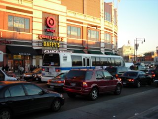
But Markowitz spotlighted another issue, probably the biggest one in the surrounding communities. “Get real about traffic and parking,” he declared as well.
That’s a tougher challenge, and Markowitz hasn’t seen many results yet. Out of 16 comments about traffic, transit, and parking his office submitted on the Atlantic Yards Draft Environmental Impact Statement (EIS), the Empire State Development Corporation (ESDC), by my count, said no to 12 and yes to two. The ESDC offered a partial yes to one comment and declared another not their issue. (Arguably, some of the "no" answers were outside the ESDC's bailiwick, as well.)
And Markowitz is the borough's cheerleader for Atlantic Yards. Tougher critics like Community Consulting Services fail the ESDC's review for ignoring or downplaying numerous issues--such as congestion pricing--that Markowitz didn’t even bring up.
That suggests that significant challenges loom.
Where's the task force?
And Markowitz has yet to act on an idea he proposed at the public hearing, “an Atlantic Yards Traffic and Transit Task Force—comprised of all relevant public agencies including the MTA, elected officials, and local community boards.”
It's understandable that progress might be uneven, since traffic and transit issues require multifaceted solutions rather than a developer’s fiat. “I drive these streets myself every day, so I understand these issues first-hand,” Markowitz said in August. “This problem is very complex and there is no silver bullet.”
The quiet BP
Still, it’s notable how quiet Markowitz has been. In a statement after PACB approval on 12/20/06, he declared unambiguously, “Brooklyn’s bright future is indeed here today.” He cited many of the project’s perceived pluses but no remaining concerns.
He didn’t take the opportunity to remind people to “get real” on traffic and transit or to point to the remaining challenges. Nor would his office do so for this article, when in early January I asked for comment on my evaluation of the ESDC's responses.
Why wouldn’t they address my wonky analysis? Essentially because they don’t trust my journalism—which has been generally critical of the project Markowitz supports--even though I'd offered to print the response verbatim.
Marty speaks
But I did catch up with Markowitz at the Brooklyn Museum a month ago, at the 1/18/07 extravaganza announcing the Barclays Center naming agreement for the Atlantic Yards arena. And despite his obvious desire to stay on message hailing Barclays, Markowitz--who, after all, is an elected official--was willing to entertain a question.
I asked him for his "interim assessment" of the traffic and parking issue about which he said we had to "get real."
His full response: "We're going to, step by step, we're going to get there. We all know, even those that are most positive about the program, as I am a hundred percent, that the issue of traffic is a serious one, and I'm confident that the city, and the private developer, and the engineering companies will do everything possible to mitigate it so that the quality of life is not impaired. I would never support anything--anything!--that I felt would impair the quality of life in our borough, whether it's your block or anybody else's, I would never. Period."
He spoke similarly in his State of the Borough address 2/1/07: "And I made a promise that I will continue to keep — to be responsive to the concerns of those in the area surrounding Atlantic Yards."
The borough president and the city and the developer understandably want to solve those problems to make the project work. But that's why the comments from his office--the mitigations he proposed but the ESDC rejected or set aside--deserve a closer look, and why Markowitz in the future should answer in specifics rather than generalities.
And the failure to get greater commitments reinforces Brian Carreira's criticism in the Brooklyn Rail this month:
That our elected officials abdicated their responsibilities to their constituents by not using the approval process and public relations to gain meaningful benefits from a developer who needed them more than they needed him is unconscionable.
Final EIS responses
Markowitz, in his written testimony, offered a thoughtful range of suggestions and solutions regarding traffic and transit, among other issues. The ESDC's responses can be found in the Response to Comments chapter of the FEIS.
Let's go through them one by one.
Downtown traffic calming? Not incorporated
Markowitz’s comment was one of several grouped as Comment 12-14. According to the ESDC’s paraphrase:
The Downtown Brooklyn Traffic Calming Project (DBTCP), conducted by NYCDOT [Department of Transportation] with the assistance of the DBTCP Task Force in response to community needs, was developed to protect residential areas adjacent to the civic and commercial core of Downtown Brooklyn from the effects of increased traffic. NYCDOT is implementing the DBTCP results. The DEIS states that “no specific measures have been identified for implementation within the study area at this time.” In fact, the NYCDOT website includes a listing of such improvements. As the City is committed to implementing the DBTCP by 2009, the effects of these improvements on the performance of the traffic network should be incorporated as part of the FEIS analyses for both (2010 and 2016) build years.
The ESDC responded:
Recommendations from NYCDOT’s Downtown Brooklyn Traffic Calming Project are subject to further detailed evaluation, analysis of impacts, and community review. In 2001, a pilot program was implemented to evaluate various candidate traffic calming measures… As discussed in the DEIS, with the exception of the conversion of Smith Street from two-way to one-way northbound operation, recommendations from the DBTCP were not incorporated into the traffic analyses as no other specific measures have been identified by NYCDOT for implementation at this time...
That seems contradicted by the DOT’s statement:
A number of improvements to Downtown Brooklyn’s transportation infrastructure have been implemented in recent months or will be implemented shortly.
Additional intersections? Nope
The Borough President (BP) stated (12-20):
The study area designated in the DEIS does not consider some of the recommendations previously made by the Borough President. In order to accurately assess the proposed project’s traffic mitigations, the Borough President recommends the NYCDOT analyze all the intersections in the DEIS and the additional intersections listed below six months after the completion of Phase 1.
Among those 13 intersections:
Jay Street/Tillary Street
Pacific Street/Nevins Street
Plaza Street/Vanderbilt Avenue
Fulton Street/Washington Avenue
The BP also suggested that NYCDOT analyze 16 streets within Community Boards 2, 6, and 8 six months after the completion of Phase II. They include:
Court Street
Classon Avenue
Smith Street
Third Avenue
Myrtle Avenue
Fourth Avenue
DeKalb Avenue
Prospect Park West
Lafayette Avenue
Vanderbilt Avenue
Washington Avenue
The ESDC responded by reiterating that it wouldn’t go further than it had already announced:
During the first year of arena operations, the project sponsors would be responsible for undertaking a program to monitor and advise NYCDOT of traffic conditions at the locations identified in the FEIS as having unmitigated significant traffic impacts. A similar monitoring program would be undertaken after full build out of the proposed project.
Closed-circuit TV monitoring? No
The BP commented (12-38):
To oversee the increasing congestion in Downtown Brooklyn that is likely to result in the future, it is recommended that an area-wide traffic surveillance system, incorporating closed circuit television (CCTV) and other technologies, be implemented for quick reaction traffic management.
The ESDC responded:
The proposed project includes a broad range of mitigation measures to help address significant traffic impacts, including a comprehensive package of demand management strategies. While implementation of an area-wide traffic surveillance system for Downtown Brooklyn could be a useful tool for NYCDOT, it would not specifically address significant traffic impacts from the proposed project.
Expanded study area for parking? No
The BP commented (12-81):
With regard to parking, the DEIS provides a study area of only one-quarter mile from the project site. As the demand for on-street parking by visitors to the development and arena are likely to overwhelm onstreet parking and displace local residents and establishments, the FEIS should expand the study area for on-street parking to within one-half mile of the proposed project.
The ESDC responded:
As discussed in Chapter 12 of the DEIS, as sufficient off-street parking capacity would be available both on-site and at existing off-site public facilities to accommodate all project parking demand in all peak periods, no significant impacts to parking conditions would result from implementation of the proposed project. However, as acknowledged in the EIS, on-street parking in the vicinity of the project site would likely be fully utilized during major events at the arena such as a Nets basketball game. A ¼-mile radius from the project site was selected as the study area for the on-street analyses as this is the area where project-generated demand for on-street parking would likely be most concentrated.
Permit parking? Not necessary
The BP, among others, commented (12-82):
A parking permit system in Downtown Brooklyn should be revisited.
Markowitz’s advocacy was cited in an 8/25/06 follow-up in the New York Times, headlined A Little Change of Tune From Atlantic Yards' Biggest Fan:
For example, I urge that my call for a parking permit system in Downtown Brooklyn be revisited.
The ESDC responded:
The May 2006 Downtown Brooklyn Residential Permit Parking Study, released by the Downtown Brooklyn Council in conjunction with DOT, found that residential neighborhoods around Downtown Brooklyn present unique challenges for implementing a residential parking permit program, and presents a set of options (one including multi-space meters) for implementing various forms of such a program. If the City were to pursue a residential parking permit program, it could solely do so as a pilot program. Permanent residential parking permit programs are authorized by specific State legislation. The DEIS does include detailed quantitative analyses of the proposed project’s potential impacts to both off-street and on-street parking. As discussed in Chapter 12, “Traffic and Parking,” of the DEIS, as sufficient off-street public parking capacity would be available both on-site and at existing off-site public parking facilities to accommodate all project demand in all peak periods, no significant adverse impacts to parking conditions would result from implementation of the proposed project. However, on-street parking in the vicinity of the project site would likely be fully utilized during major events at the arena such as a Nets basketball game.
Free parking for residents who lose spaces? No
The BP commented (12-92):
Residents, whose on-street parking would be displaced within ¼-mile of the project site, should be provided free or inexpensive parking in the project’s off-street parking facilities on event nights.
The ESDC responded:
The DEIS acknowledges that it is likely that during an arena event, much of the on-street parking capacity available in the immediate vicinity of the arena would be utilized by project-generated demand. Parking demand would be satisfied by a combination of on- and off-site parking facilities, and therefore, there would be no significant adverse parking impacts resulting from the proposed project. It is not the responsibility of the project sponsors to pay for existing residents to park off-street or to provide them with off-street parking.
Studies to monitor traffic conditions? Sort of
The BP commented (12-123):
As conditions before the 2010 and 2016 build years evolve, before and after studies should be conducted to verify projected conditions. An ongoing traffic monitoring plan should be implemented so that changes in traffic volumes can be identified and their affect on the area’s traffic projections analyzed, and plans modified, if necessary.
The ESDC did not say it would conduct the four specific studies Markowitz requested, but indicated that some studies would be conducted:
During the first year of arena operations, the project sponsors would undertake a program to monitor and advise DOT of traffic and pedestrian conditions at the locations identified in the FEIS as having unmitigated significant traffic impacts. A similar monitoring program would be undertaken after full build-out of the proposed project. Additionally, in accordance with Chapter 19, “Mitigation,” in the FEIS, the project sponsors would conduct origin/destination and mode choice surveys of fans attending a Nets game midway through the first Nets season at the arena. The exact scope of the monitoring program would be developed in coordination with, and approved by DOT.
DOT simulation? It’s up to them
The BP commented (12-124):
The simulation of traffic behavior on the area’s street network is necessary to serve as a tool for managing it on an on-going basis. The NYC DOT should develop an area-wide computerized traffic simulation model that is linked to the Best Practice Model (BPM) managed by the New York Metropolitan Transportation Council (NYMTC). It would be used to confirm the effectiveness of all the above and establish a comprehensive traffic simulation of all changes in land use and the street network in greater Downtown Brooklyn.
The ESDC responded:
Comment noted.
Market testing? Yes
The BP commented (12-125):
Market testing of demand management techniques needs to continue to obtain greater confidence in the assumptions and the effectiveness of the options, and to assist in the refinement of measures after the FEIS is completed.
The ESDC responded:
As discussed in the FEIS, the demand management strategies included as part of the proposed project’s traffic mitigation plan would be monitored to determine their effectiveness at lowering the auto mode share for a Nets basketball game at the arena. This monitoring would include origin/destination and mode choice surveys of arena patrons midway through the first basketball season. Based on the data collected, the mix of demand management strategies and remote parking could be adjusted to improve the efficacy of the mitigation.
Subway guidelines change? No
Among others, the BP criticized estimates of subway capacity (13-3):
Given riders’ concerns about overcrowding, the use of NYC Transit’s loading guidelines may not be the best measure of successfully attracting additional riders and diverting them from auto use and reducing street congestion. The FEIS should evaluate a comfortable level of service for all subway lines through Downtown Brooklyn since encouraging travel via public transit to and from the arena site and thereby reducing auto usage is one of the overarching goals of the project.
The ESDC responded:
The DEIS properly used NYCT’s loading guideline of three square feet per standing passenger. A standard of four square feet per standing passenger is not used by NYCT. The guidelines used in the DEIS are MTA Board-approved and are used consistently throughout the system. The FEIS has been revised to clarify this assumption. Service cuts are not currently under consideration by the MTA; thus, it would not be appropriate to reflect them in the analysis.
Trolley loop? Nope
Markowitz’s comments about trolleys were ignored in the FEIS:
Other transportation/traffic mitigation measures the FEIS should consider using traffic agents and implementing a trolley loop system connecting all mass transit…A trolley loop can more effectively connect the transit locations in downtown Brooklyn encouraging more mass transit use and decreasing car use.
However, others commented (13-16):
The MTA should consider a trolley loop to bring people to and from the stadium. Park and ride would be a benefit.
The ESDC responded:
The construction of a new trolley line is outside the purview of the proposed project. However, as discussed in Chapter 19 of the FEIS, as part of the proposed project’s traffic mitigation plan, a remote parking program with price incentives and free bus shuttle service for arena patrons would be established at two parking facilities on the periphery of the study area. In addition, a free charter bus service would be implemented to transport Nets fans to the arena from park & ride facilities on Staten Island.
Bus rapid transit? Not yet
The BP called for an examination of bus rapid transit (13-34):
The FEIS should analyze the implementation of a peak hour bus lane along Flatbush Avenue between Grand Army Plaza and Livingston Street, similar to the one currently on Livingston Street. Accordingly, the Bus Rapid Transit (BRT) study consideration of corridor improvements in this section of Flatbush Avenue should be accelerated.
The ESDC said no dice:
NYCDOT and MTA have recently proposed implementation of a pilot bus rapid transit program that would include implementation of a route in Brooklyn along Nostrand, Bedford and Rogers Avenues that does not traverse the project’s study area. Though studied, there are no present plans to implement a pilot bus rapid transit program along Flatbush Avenue. The proposed project, including the proposed lay-by lanes adjacent to the arena block, is not expected to preclude the installation of bus rapid transit lanes or stops should they be considered in the future….
Transfer connection? No
The BP commented (13-38):
Downtown Brooklyn subway stations currently without transfer capacity need improved connections to support anticipated growth. One option is to provide a Hoyt Street Connector to and from the Hoyt Street 2 and 3 station and the Hoyt-Schermerhorn A, C and G station. This passageway is one alternative to provide the missing connection between the two stations in Downtown Brooklyn. It would also provide a means for G train riders to transfer to the 2 and 3 trains for direct access to the “Urban Room.” The proposed passageway would connect and widen the Livingston Street entrance of the Hoyt-Schermerhorn station with the Hoyt Street station on Fulton Street, or use the closed corridor to Macy’s Department Store.
The ESDC responded:
As noted in the FEIS, the project site would be accessible by C train via the Lafayette Avenue IND and Clinton-Washington Avenues IND stations, and by G train via the Fulton Street IND station. All three of these stations are less than ¼-mile from the project site. While a new two-block-long passageway connecting the Hoyt Street IRT and Hoyt- Schermerhorn Streets IND stations would provide another option for IND subway riders en route to the project site, it is not necessary to mitigate a significant subway impact due to the proposed project.
LIRR train frequency? Nope
The BP commented (13-39):
With regard to the Long Island Rail Road, the DEIS does not discuss operating improvements for LIRR services between Jamaica and Flatbush Terminal. The FEIS should consider LIRR train frequency.
The ESDC responded:
The LIRR schedule is discussed in Chapter 13, “Transit and Pedestrians” of the DEIS. The DEIS concludes that there would be sufficient capacity to accommodate project demand.
(See p. 58 of that chapter.)
ADA compliant? Yes
The BP commented (13-40):
Over the last 35 years, the MTA has made significant strides in improving access for the elderly and physically-challenged, including making all buses ADA compliant, and developing its Key Station Plan to make 100 NYC Transit subway stations ADA compliant by 2020. The Atlantic Avenue/Pacific Street station complex is a Key Station that is currently ADA-compliant. However, wheelchair bound subway riders going to Atlantic Avenue station are advised to be in the 6th car on the 4, 5 trains. Therefore, 2 and 3 train riders are advised to change to the 4, 5 train at the Nevins Street Station. The FEIS should analyze improvements for handicapped elevator access from the platform.
The ESDC responded:
All of the platforms at the Atlantic Avenue IRT station are currently accessible to the mobility impaired via elevators that connect each platform to the existing concourse below the northen end of the station. The proposed Urban Room subway entrance would include a new ADA elevator from street level to a new control area at the south end of the station. From this location, an ADA-compliant ramp would provide direct access to the Manhattan-bound 2,3 platform from where mobility impaired passengers would then have access to other platforms via elevators to the existing concourse.
Through ticketing? No
The BP commented (13-41):
The FEIS should examine the creation of a thru-ticketing arrangement for LIRR riders which enables them to pass through the paid zone for the subway to reach the Urban Room without payment of a subway fare. Otherwise, project generated trips via the LIRR would be required to use the existing entrance to LIRR’s street level concourse on Flatbush Avenue. Both a through-ticketing arrangement for LIRR riders and a connection between the Hoyt Street and Hoyt-Schermerhorn Streets subway stations would require re-evaluation of proposed Urban Room escalators E1 and E2.
The ESDC responded:
MTA NYC Transit has indicated that a through-ticketing arrangement for game days is not feasible with current MetroCard technology. In addition, it would not be practical to physically separate LIRR passengers walking through the paid area from subway passengers due to space and circulation constraints within the station. For the purposes of the traffic and pedestrian analyses in the DEIS, it is assumed that all of the LIRR demand would occur on sidewalks and crosswalks connecting the project site with street-level entrances to the LIRR’s Atlantic Terminal.
Neither a new connection between the Hoyt Street and Hoyt- Schermerhorn Streets subway stations nor a through-ticketing arrangement for LIRR passengers is contemplated as part of the proposed project, nor are they required as mitigation or otherwise under consideration by NYC Transit.
Pedestrian safety study? No
The BP commented (13-47):
The FEIS should include a pedestrian/traffic safety study, consistent with any applicable CEQRA/SEQRA thresholds for each intersection that has an increase in pedestrian and bicycle volumes attributable to this project, including those not currently disclosed.
The ESDC responded:
The DEIS examines accident and safety issues at a total of 20 intersections in the vicinity of the project site. It is at these intersections where new vehicular, pedestrian and bicycle trips generated by the proposed project are expected to be most concentrated, and where the potential for increased conflicts between these modes would be greatest. The analysis focuses on those intersections with relatively high accident rates (such as Atlantic/Flatbush Avenues and Atlantic/Vanderbilt Avenues), as well as locations where the proposed project would alter traffic flow patterns (Flatbush Avenue/Pacific Street, for example). Traffic, and especially pedestrian flows generated by the proposed project, become increasingly dispersed with increasing distance from the project site. The potential for increased vehicle and pedestrian conflicts from these new trips would therefore also be lower at intersections more distant from the project site.
Markowitz called for the Williamsburgh Savings Bank to remain the borough’s tallest building. That took longer. In a well-timed “concession” on the day of the 12/20/06 vote by the Public Authorities Control Board (PACB), the developer agreed to bring Frank Gehry's "Miss Brooklyn" from 620 feet to 511 feet.
(However, as noted, the view of the bank, which Forest City Ratner promised to protect in its 12/10/03 project announcement, remains blocked from the crucial Flatbush Avenue corridor. And we don't know the bulk of Miss Brooklyn.)
 Getting real?
But Markowitz spotlighted another issue, probably the biggest one in the surrounding communities. “Get real about traffic and parking,” he declared as well.
That’s a tougher challenge, and Markowitz hasn’t seen many results yet. Out of 16 comments about traffic, transit, and parking his office submitted on the Atlantic Yards Draft Environmental Impact Statement (EIS), the Empire State Development Corporation (ESDC), by my count, said no to 12 and yes to two. The ESDC offered a partial yes to one comment and declared another not their issue. (Arguably, some of the "no" answers were outside the ESDC's bailiwick, as well.)
And Markowitz is the borough's cheerleader for Atlantic Yards. Tougher critics like Community Consulting Services fail the ESDC's review for ignoring or downplaying numerous issues--such as congestion pricing--that Markowitz didn’t even bring up.
That suggests that significant challenges loom.
Where's the task force?
And Markowitz has yet to act on an idea he proposed at the public hearing, “an Atlantic Yards Traffic and Transit Task Force—comprised of all relevant public agencies including the MTA, elected officials, and local community boards.”
It's understandable that progress might be uneven, since traffic and transit issues require multifaceted solutions rather than a developer’s fiat. “I drive these streets myself every day, so I understand these issues first-hand,” Markowitz said in August. “This problem is very complex and there is no silver bullet.”
The quiet BP
Still, it’s notable how quiet Markowitz has been. In a statement after PACB approval on 12/20/06, he declared unambiguously, “Brooklyn’s bright future is indeed here today.” He cited many of the project’s perceived pluses but no remaining concerns.
He didn’t take the opportunity to remind people to “get real” on traffic and transit or to point to the remaining challenges. Nor would his office do so for this article, when in early January I asked for comment on my evaluation of the ESDC's responses.
Why wouldn’t they address my wonky analysis? Essentially because they don’t trust my journalism—which has been generally critical of the project Markowitz supports--even though I'd offered to print the response verbatim.
Marty speaks
But I did catch up with Markowitz at the Brooklyn Museum a month ago, at the 1/18/07 extravaganza announcing the Barclays Center naming agreement for the Atlantic Yards arena. And despite his obvious desire to stay on message hailing Barclays, Markowitz--who, after all, is an elected official--was willing to entertain a question.
I asked him for his "interim assessment" of the traffic and parking issue about which he said we had to "get real."
His full response: "We're going to, step by step, we're going to get there. We all know, even those that are most positive about the program, as I am a hundred percent, that the issue of traffic is a serious one, and I'm confident that the city, and the private developer, and the engineering companies will do everything possible to mitigate it so that the quality of life is not impaired. I would never support anything--anything!--that I felt would impair the quality of life in our borough, whether it's your block or anybody else's, I would never. Period."
He spoke similarly in his State of the Borough address 2/1/07: "And I made a promise that I will continue to keep — to be responsive to the concerns of those in the area surrounding Atlantic Yards."
The borough president and the city and the developer understandably want to solve those problems to make the project work. But that's why the comments from his office--the mitigations he proposed but the ESDC rejected or set aside--deserve a closer look, and why Markowitz in the future should answer in specifics rather than generalities.
And the failure to get greater commitments reinforces Brian Carreira's criticism in the Brooklyn Rail this month:
That our elected officials abdicated their responsibilities to their constituents by not using the approval process and public relations to gain meaningful benefits from a developer who needed them more than they needed him is unconscionable.
Final EIS responses
Markowitz, in his written testimony, offered a thoughtful range of suggestions and solutions regarding traffic and transit, among other issues. The ESDC's responses can be found in the Response to Comments chapter of the FEIS.
Let's go through them one by one.
Downtown traffic calming? Not incorporated
Markowitz’s comment was one of several grouped as Comment 12-14. According to the ESDC’s paraphrase:
The Downtown Brooklyn Traffic Calming Project (DBTCP), conducted by NYCDOT [Department of Transportation] with the assistance of the DBTCP Task Force in response to community needs, was developed to protect residential areas adjacent to the civic and commercial core of Downtown Brooklyn from the effects of increased traffic. NYCDOT is implementing the DBTCP results. The DEIS states that “no specific measures have been identified for implementation within the study area at this time.” In fact, the NYCDOT website includes a listing of such improvements. As the City is committed to implementing the DBTCP by 2009, the effects of these improvements on the performance of the traffic network should be incorporated as part of the FEIS analyses for both (2010 and 2016) build years.
The ESDC responded:
Recommendations from NYCDOT’s Downtown Brooklyn Traffic Calming Project are subject to further detailed evaluation, analysis of impacts, and community review. In 2001, a pilot program was implemented to evaluate various candidate traffic calming measures… As discussed in the DEIS, with the exception of the conversion of Smith Street from two-way to one-way northbound operation, recommendations from the DBTCP were not incorporated into the traffic analyses as no other specific measures have been identified by NYCDOT for implementation at this time...
That seems contradicted by the DOT’s statement:
A number of improvements to Downtown Brooklyn’s transportation infrastructure have been implemented in recent months or will be implemented shortly.
Additional intersections? Nope
The Borough President (BP) stated (12-20):
The study area designated in the DEIS does not consider some of the recommendations previously made by the Borough President. In order to accurately assess the proposed project’s traffic mitigations, the Borough President recommends the NYCDOT analyze all the intersections in the DEIS and the additional intersections listed below six months after the completion of Phase 1.
Among those 13 intersections:
Jay Street/Tillary Street
Pacific Street/Nevins Street
Plaza Street/Vanderbilt Avenue
Fulton Street/Washington Avenue
The BP also suggested that NYCDOT analyze 16 streets within Community Boards 2, 6, and 8 six months after the completion of Phase II. They include:
Court Street
Classon Avenue
Smith Street
Third Avenue
Myrtle Avenue
Fourth Avenue
DeKalb Avenue
Prospect Park West
Lafayette Avenue
Vanderbilt Avenue
Washington Avenue
The ESDC responded by reiterating that it wouldn’t go further than it had already announced:
During the first year of arena operations, the project sponsors would be responsible for undertaking a program to monitor and advise NYCDOT of traffic conditions at the locations identified in the FEIS as having unmitigated significant traffic impacts. A similar monitoring program would be undertaken after full build out of the proposed project.
Closed-circuit TV monitoring? No
The BP commented (12-38):
To oversee the increasing congestion in Downtown Brooklyn that is likely to result in the future, it is recommended that an area-wide traffic surveillance system, incorporating closed circuit television (CCTV) and other technologies, be implemented for quick reaction traffic management.
The ESDC responded:
The proposed project includes a broad range of mitigation measures to help address significant traffic impacts, including a comprehensive package of demand management strategies. While implementation of an area-wide traffic surveillance system for Downtown Brooklyn could be a useful tool for NYCDOT, it would not specifically address significant traffic impacts from the proposed project.
Expanded study area for parking? No
The BP commented (12-81):
With regard to parking, the DEIS provides a study area of only one-quarter mile from the project site. As the demand for on-street parking by visitors to the development and arena are likely to overwhelm onstreet parking and displace local residents and establishments, the FEIS should expand the study area for on-street parking to within one-half mile of the proposed project.
The ESDC responded:
As discussed in Chapter 12 of the DEIS, as sufficient off-street parking capacity would be available both on-site and at existing off-site public facilities to accommodate all project parking demand in all peak periods, no significant impacts to parking conditions would result from implementation of the proposed project. However, as acknowledged in the EIS, on-street parking in the vicinity of the project site would likely be fully utilized during major events at the arena such as a Nets basketball game. A ¼-mile radius from the project site was selected as the study area for the on-street analyses as this is the area where project-generated demand for on-street parking would likely be most concentrated.
Permit parking? Not necessary
The BP, among others, commented (12-82):
A parking permit system in Downtown Brooklyn should be revisited.
Markowitz’s advocacy was cited in an 8/25/06 follow-up in the New York Times, headlined A Little Change of Tune From Atlantic Yards' Biggest Fan:
For example, I urge that my call for a parking permit system in Downtown Brooklyn be revisited.
The ESDC responded:
The May 2006 Downtown Brooklyn Residential Permit Parking Study, released by the Downtown Brooklyn Council in conjunction with DOT, found that residential neighborhoods around Downtown Brooklyn present unique challenges for implementing a residential parking permit program, and presents a set of options (one including multi-space meters) for implementing various forms of such a program. If the City were to pursue a residential parking permit program, it could solely do so as a pilot program. Permanent residential parking permit programs are authorized by specific State legislation. The DEIS does include detailed quantitative analyses of the proposed project’s potential impacts to both off-street and on-street parking. As discussed in Chapter 12, “Traffic and Parking,” of the DEIS, as sufficient off-street public parking capacity would be available both on-site and at existing off-site public parking facilities to accommodate all project demand in all peak periods, no significant adverse impacts to parking conditions would result from implementation of the proposed project. However, on-street parking in the vicinity of the project site would likely be fully utilized during major events at the arena such as a Nets basketball game.
Free parking for residents who lose spaces? No
The BP commented (12-92):
Residents, whose on-street parking would be displaced within ¼-mile of the project site, should be provided free or inexpensive parking in the project’s off-street parking facilities on event nights.
The ESDC responded:
The DEIS acknowledges that it is likely that during an arena event, much of the on-street parking capacity available in the immediate vicinity of the arena would be utilized by project-generated demand. Parking demand would be satisfied by a combination of on- and off-site parking facilities, and therefore, there would be no significant adverse parking impacts resulting from the proposed project. It is not the responsibility of the project sponsors to pay for existing residents to park off-street or to provide them with off-street parking.
Studies to monitor traffic conditions? Sort of
The BP commented (12-123):
As conditions before the 2010 and 2016 build years evolve, before and after studies should be conducted to verify projected conditions. An ongoing traffic monitoring plan should be implemented so that changes in traffic volumes can be identified and their affect on the area’s traffic projections analyzed, and plans modified, if necessary.
The ESDC did not say it would conduct the four specific studies Markowitz requested, but indicated that some studies would be conducted:
During the first year of arena operations, the project sponsors would undertake a program to monitor and advise DOT of traffic and pedestrian conditions at the locations identified in the FEIS as having unmitigated significant traffic impacts. A similar monitoring program would be undertaken after full build-out of the proposed project. Additionally, in accordance with Chapter 19, “Mitigation,” in the FEIS, the project sponsors would conduct origin/destination and mode choice surveys of fans attending a Nets game midway through the first Nets season at the arena. The exact scope of the monitoring program would be developed in coordination with, and approved by DOT.
DOT simulation? It’s up to them
The BP commented (12-124):
The simulation of traffic behavior on the area’s street network is necessary to serve as a tool for managing it on an on-going basis. The NYC DOT should develop an area-wide computerized traffic simulation model that is linked to the Best Practice Model (BPM) managed by the New York Metropolitan Transportation Council (NYMTC). It would be used to confirm the effectiveness of all the above and establish a comprehensive traffic simulation of all changes in land use and the street network in greater Downtown Brooklyn.
The ESDC responded:
Comment noted.
Market testing? Yes
The BP commented (12-125):
Market testing of demand management techniques needs to continue to obtain greater confidence in the assumptions and the effectiveness of the options, and to assist in the refinement of measures after the FEIS is completed.
The ESDC responded:
As discussed in the FEIS, the demand management strategies included as part of the proposed project’s traffic mitigation plan would be monitored to determine their effectiveness at lowering the auto mode share for a Nets basketball game at the arena. This monitoring would include origin/destination and mode choice surveys of arena patrons midway through the first basketball season. Based on the data collected, the mix of demand management strategies and remote parking could be adjusted to improve the efficacy of the mitigation.
Subway guidelines change? No
Among others, the BP criticized estimates of subway capacity (13-3):
Given riders’ concerns about overcrowding, the use of NYC Transit’s loading guidelines may not be the best measure of successfully attracting additional riders and diverting them from auto use and reducing street congestion. The FEIS should evaluate a comfortable level of service for all subway lines through Downtown Brooklyn since encouraging travel via public transit to and from the arena site and thereby reducing auto usage is one of the overarching goals of the project.
The ESDC responded:
The DEIS properly used NYCT’s loading guideline of three square feet per standing passenger. A standard of four square feet per standing passenger is not used by NYCT. The guidelines used in the DEIS are MTA Board-approved and are used consistently throughout the system. The FEIS has been revised to clarify this assumption. Service cuts are not currently under consideration by the MTA; thus, it would not be appropriate to reflect them in the analysis.
Trolley loop? Nope
Markowitz’s comments about trolleys were ignored in the FEIS:
Other transportation/traffic mitigation measures the FEIS should consider using traffic agents and implementing a trolley loop system connecting all mass transit…A trolley loop can more effectively connect the transit locations in downtown Brooklyn encouraging more mass transit use and decreasing car use.
However, others commented (13-16):
The MTA should consider a trolley loop to bring people to and from the stadium. Park and ride would be a benefit.
The ESDC responded:
The construction of a new trolley line is outside the purview of the proposed project. However, as discussed in Chapter 19 of the FEIS, as part of the proposed project’s traffic mitigation plan, a remote parking program with price incentives and free bus shuttle service for arena patrons would be established at two parking facilities on the periphery of the study area. In addition, a free charter bus service would be implemented to transport Nets fans to the arena from park & ride facilities on Staten Island.
Bus rapid transit? Not yet
The BP called for an examination of bus rapid transit (13-34):
The FEIS should analyze the implementation of a peak hour bus lane along Flatbush Avenue between Grand Army Plaza and Livingston Street, similar to the one currently on Livingston Street. Accordingly, the Bus Rapid Transit (BRT) study consideration of corridor improvements in this section of Flatbush Avenue should be accelerated.
The ESDC said no dice:
NYCDOT and MTA have recently proposed implementation of a pilot bus rapid transit program that would include implementation of a route in Brooklyn along Nostrand, Bedford and Rogers Avenues that does not traverse the project’s study area. Though studied, there are no present plans to implement a pilot bus rapid transit program along Flatbush Avenue. The proposed project, including the proposed lay-by lanes adjacent to the arena block, is not expected to preclude the installation of bus rapid transit lanes or stops should they be considered in the future….
Transfer connection? No
The BP commented (13-38):
Downtown Brooklyn subway stations currently without transfer capacity need improved connections to support anticipated growth. One option is to provide a Hoyt Street Connector to and from the Hoyt Street 2 and 3 station and the Hoyt-Schermerhorn A, C and G station. This passageway is one alternative to provide the missing connection between the two stations in Downtown Brooklyn. It would also provide a means for G train riders to transfer to the 2 and 3 trains for direct access to the “Urban Room.” The proposed passageway would connect and widen the Livingston Street entrance of the Hoyt-Schermerhorn station with the Hoyt Street station on Fulton Street, or use the closed corridor to Macy’s Department Store.
The ESDC responded:
As noted in the FEIS, the project site would be accessible by C train via the Lafayette Avenue IND and Clinton-Washington Avenues IND stations, and by G train via the Fulton Street IND station. All three of these stations are less than ¼-mile from the project site. While a new two-block-long passageway connecting the Hoyt Street IRT and Hoyt- Schermerhorn Streets IND stations would provide another option for IND subway riders en route to the project site, it is not necessary to mitigate a significant subway impact due to the proposed project.
LIRR train frequency? Nope
The BP commented (13-39):
With regard to the Long Island Rail Road, the DEIS does not discuss operating improvements for LIRR services between Jamaica and Flatbush Terminal. The FEIS should consider LIRR train frequency.
The ESDC responded:
The LIRR schedule is discussed in Chapter 13, “Transit and Pedestrians” of the DEIS. The DEIS concludes that there would be sufficient capacity to accommodate project demand.
(See p. 58 of that chapter.)
ADA compliant? Yes
The BP commented (13-40):
Over the last 35 years, the MTA has made significant strides in improving access for the elderly and physically-challenged, including making all buses ADA compliant, and developing its Key Station Plan to make 100 NYC Transit subway stations ADA compliant by 2020. The Atlantic Avenue/Pacific Street station complex is a Key Station that is currently ADA-compliant. However, wheelchair bound subway riders going to Atlantic Avenue station are advised to be in the 6th car on the 4, 5 trains. Therefore, 2 and 3 train riders are advised to change to the 4, 5 train at the Nevins Street Station. The FEIS should analyze improvements for handicapped elevator access from the platform.
The ESDC responded:
All of the platforms at the Atlantic Avenue IRT station are currently accessible to the mobility impaired via elevators that connect each platform to the existing concourse below the northen end of the station. The proposed Urban Room subway entrance would include a new ADA elevator from street level to a new control area at the south end of the station. From this location, an ADA-compliant ramp would provide direct access to the Manhattan-bound 2,3 platform from where mobility impaired passengers would then have access to other platforms via elevators to the existing concourse.
Through ticketing? No
The BP commented (13-41):
The FEIS should examine the creation of a thru-ticketing arrangement for LIRR riders which enables them to pass through the paid zone for the subway to reach the Urban Room without payment of a subway fare. Otherwise, project generated trips via the LIRR would be required to use the existing entrance to LIRR’s street level concourse on Flatbush Avenue. Both a through-ticketing arrangement for LIRR riders and a connection between the Hoyt Street and Hoyt-Schermerhorn Streets subway stations would require re-evaluation of proposed Urban Room escalators E1 and E2.
The ESDC responded:
MTA NYC Transit has indicated that a through-ticketing arrangement for game days is not feasible with current MetroCard technology. In addition, it would not be practical to physically separate LIRR passengers walking through the paid area from subway passengers due to space and circulation constraints within the station. For the purposes of the traffic and pedestrian analyses in the DEIS, it is assumed that all of the LIRR demand would occur on sidewalks and crosswalks connecting the project site with street-level entrances to the LIRR’s Atlantic Terminal.
Neither a new connection between the Hoyt Street and Hoyt- Schermerhorn Streets subway stations nor a through-ticketing arrangement for LIRR passengers is contemplated as part of the proposed project, nor are they required as mitigation or otherwise under consideration by NYC Transit.
Pedestrian safety study? No
The BP commented (13-47):
The FEIS should include a pedestrian/traffic safety study, consistent with any applicable CEQRA/SEQRA thresholds for each intersection that has an increase in pedestrian and bicycle volumes attributable to this project, including those not currently disclosed.
The ESDC responded:
The DEIS examines accident and safety issues at a total of 20 intersections in the vicinity of the project site. It is at these intersections where new vehicular, pedestrian and bicycle trips generated by the proposed project are expected to be most concentrated, and where the potential for increased conflicts between these modes would be greatest. The analysis focuses on those intersections with relatively high accident rates (such as Atlantic/Flatbush Avenues and Atlantic/Vanderbilt Avenues), as well as locations where the proposed project would alter traffic flow patterns (Flatbush Avenue/Pacific Street, for example). Traffic, and especially pedestrian flows generated by the proposed project, become increasingly dispersed with increasing distance from the project site. The potential for increased vehicle and pedestrian conflicts from these new trips would therefore also be lower at intersections more distant from the project site.
Comments
Post a Comment